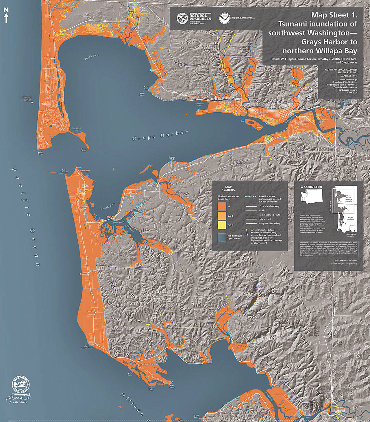
The state Department of Natural Resources has released new Tsunami Inundation Hazard Maps for Southwest Washington in advance of the upcoming Tsunami Road show that will take place next month in Westport and Ocean Shores.
The new maps are a bit different than previous tsunami inundation mapping, according to Charles Wallace, deputy director of Grays Harbor County Emergency Management. Previous inundation mapping was based upon the last Cascadia Subduction Zone earthquake from 1700.
“This new study and modeling is based upon a simulated 2,500-year event, from a magnitude 9.0 earthquake. This event produces a farther reaching tsunami inundation scenario,” Wallace said in a media release
“Although the 2,500 year-event brings more tsunami inundation, the response from all people along the coast is the same. Once you feel the earthquake, drop, cover and hold on until the ground shaking stops and then move to high ground immediately, whether it is a multi-story home, business, tower, or up a hillside. Do not attempt to run from the interior of a building during the earthquake as it increases your chances for injury. Always wait until the ground stops shaking. Remember, there will be aftershocks.”
The first tsunami waves (a minimum of four are expected) will arrive within 15-25 minutes following the quake. Aftershocks may produce additional tsunami waves in coastal areas.
Wave heights along the beaches will vary depending on the bathymetry of the coastline, however, “the amount and level of inundation is our greatest concern,” Wallace said. The DNR provided Grays Harbor Emergency Management some approximate inundation depths for this 2,500-year event for our coastal areas:
Ocean City:
Screamin’ Eagle Campground: 45.1 ft.
Ocean Shores:
Spinnaker Park: 28.5 ft.
Bill’s Spit (Peninsula Ct. SE): 4.7 ft.
Elks Lodge: 21.1 ft.
Point Brown Ave at E Chance a La Mer NE roundabout: 27.2 ft.
Westport:
Westport Viewing Tower: 12.5 ft.
W Ocean Ave roundabout: 18.4 ft.
Westport City Park: 6.5 ft.
Grayland:
Beachcomber Grocery and Deli: 26.2 ft.
Security State Bank: 22.2 ft.
Areas of deepest on-land inundation
North Jetty (Ocean Shores): 67 ft.
Damon Point (Ocean Shores): 61 ft.
Ocean City: 57 ft.
The modeling takes into account mean high tide and subsidence (4-6 feet).”If we are at low tide when the tsunami arrives, the event will have a reduced impact, however, if we are at higher tides (King Tides, Higher Astronomical Tides), the event could have a greater impact,” Wallace noted.
For a large earthquake and tsunami event, such as this modeled event, there is the possibility of pre-quakes, the main 9.0 earthquake and hundreds of aftershocks, some potentially capable of producing additional tsunami waves.
The state-sponsored Tsunami Roadshow will be held April 11 — at noon at the Ocosta Junior-Senior High School Library, 2580 Montesano St, Westport; and at 6 p.m .at the Ocean Shores Convention Center, 120 W. Chance a La Mer, NW Ocean Shores.
To view the maps online: https://washingtonstategeology.wordpress.com/2018/03/26/newly-published-southwest-washington-tsunami-inundation-hazard-maps/