Tsunami and earthquake experts will return this month for presentations and discussions on tsunami vertical evacuation structures, potential earthquake early warning systems and survival strategies.
Officials from the Washington Emergency Management Division will be joined by the Washington Geological Survey, the National Weather Service, Washington Sea Grant and local emergency management officials in the 90-minute presentations, which will include time for questions.
Public presentations are:
• Noon, Wednesday, April 10 at the Ocean Shores Convention Center, 120 W. Chance a La Mer.
• 6:30 p.m., Wednesday, April 10 at Aberdeen (J.M. Weatherwax) High School, 410 N. G. St.
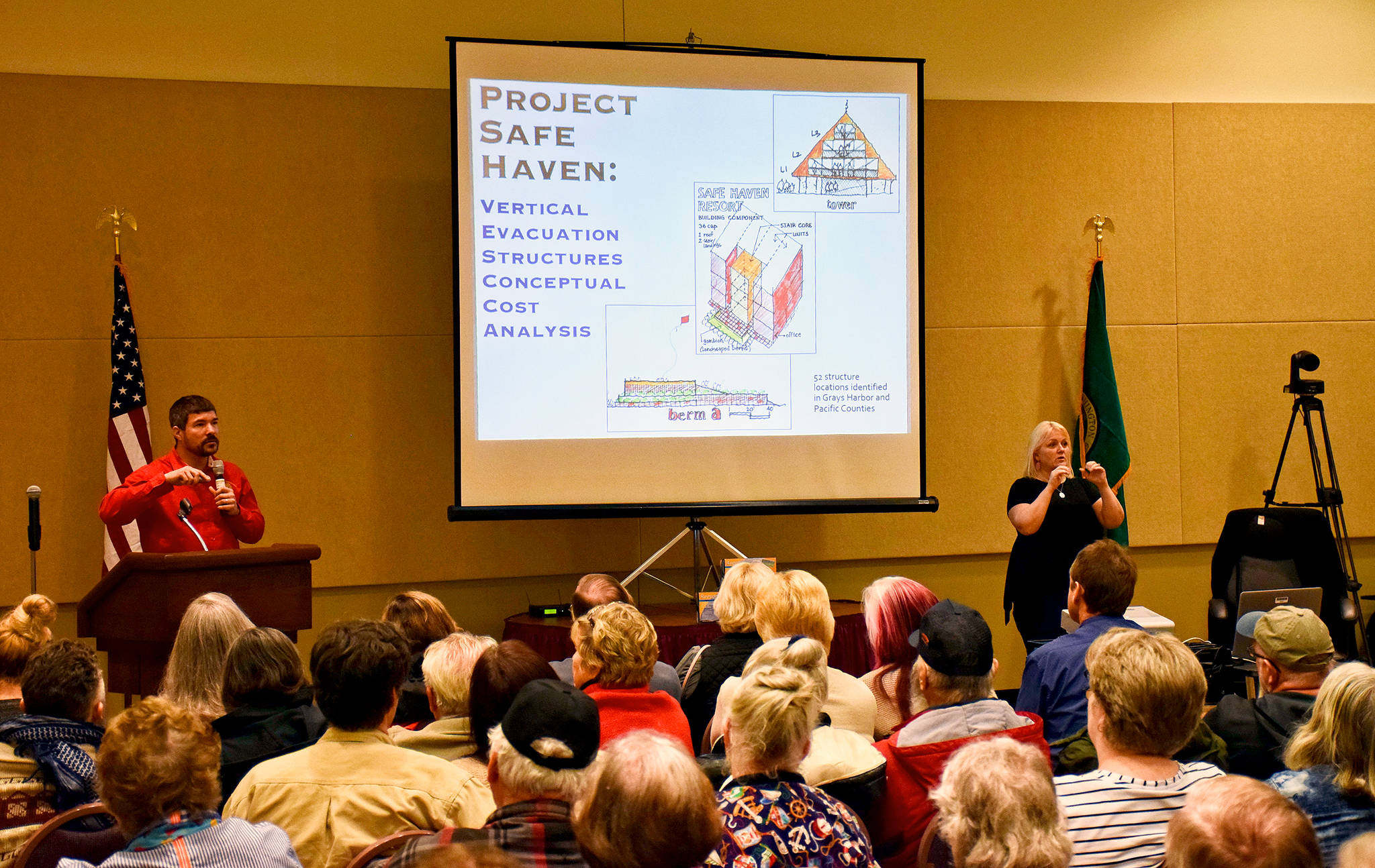
This is the third year for what’s been nicknamed the “tsunami roadshow,” and the fourth such presentation in Ocean Shores. The city last year made a formal application to the Federal Emergency Management Agency for funding of the first tsunami vertical evacuation structure on the North Beach (to be located near Ocean Shores Elementary School), and the state House of Representatives last week included $500,000 in its budget that now goes over to the Senate.
“The goal this year is to make sure as many people know and understand what tsunami alerts are, how to receive them, and what to do to survive a tsunami,” said Geologic Hazards Program Supervisor Maximilian Dixon with the Washington Emergency Management Division.
Washington currently has 72 All Hazard Alert Broadcast sirens along the coast with federal funding to add one at the Quinault Indian Nation and three in Skagit County later this year. But Dixon says the state needs at least 40 more to fill key gaps along the coast. The governor’s proposed budget this year would provide state funding for another 15 sirens.
Dixon has also been working with communities to apply for federal grant funds to build more tsunami vertical evacuation structures. In addition to the Ocean Shores proposal, grant applications have been received for potential structures in Westport and Aberdeen.
There’s only one vertical evacuation structure at Ocosta Elementary near Westport with a second one undergoing construction by the Shoalwater Bay Tribe.
All of the tsunami sirens recently underwent an upgrade and now feature voice messages in both English and Spanish with future upgrades planned to increase reliability. On March 20, the state teamed with federal officials to conduct a workshop with emergency managers around Puget Sound and the outer coast to look at tsunami response strategies. Wireless Emergency Alert Systems have also been implemented for the coastal areas to potentially send out messages to residents and visitors to head to high ground if a tsunami is coming.
“We’ve made improvements that will help us communicate to people all over the coast, but, remember, if you feel an earthquake, and you’re on the coast, drop, cover and hold on,” Dixon said. “Then as soon as it is safe to move, head immediately to high ground or inland. Don’t wait for that text message. Don’t wait for the sirens to go off.”
More information is at mil.wa.gov/tsunami.
Here are the presenters scheduled for the Ocean Shores forum:
• Dixon is the Earthquake Program Manager for the Washington State Military Department’s Emergency Management Division (WA EMD). He manages the Earthquake, Tsunami and Volcano Programs and is responsible for coordinating the seismic and associated hazard risk reduction efforts between federal, state, tribal, and local partners.
• Keily Yemm is the Tsunami Program Coordinator for the Washington State Military Department’s Emergency Management Division (WA EMD). Through an annual NOAA/NWS Tsunami Activity Grant, Keily coordinates a wide variety of projects that include AHAB siren installation and maintenance, tsunami inundation and evacuation modeling and mapping, support for TsunamiReady community status, and development of vertical evacuation structure best practices.
• Daniel Eungard is a licensed geologist who has worked at the Washington Geological Survey for 5 years. Utilizing his skills both as a geologist and GIS analyst, he manages the data, creates map products, and authored or co-authored publications related to tsunami inundation and pedestrian evacuation models.
Additionally, he serves as the data manager for the Survey’s geotechnical document repository and subsurface database.
• Carrie Garrison-Laney is the Tsunami and Coastal Resilience Liaison/Environmental Outreach Specialist at Washington Sea Grant, College of the Environment, University of Washington. Carrie’s expertise is in the identification and characterization of tsunami deposits, tsunami modeling, scientific communication, and scientific education.